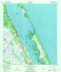
1949 Map of Sebastian
USGS Topo · Published 1971About this map
Sebastian and the Florida East Coast railway corridor dominate this coastal survey, where the Atlantic shoreline meets the intricate lagoons of the Indian River. The landscape is defined by its maritime and agricultural connectivity, featuring the Sebastian Municipal Airport and a specialized Fish Hatchery near Roseland. The map reveals a complex network of islands and sloughs, including Pauls Island, Nelson Island, and Roosevelt Island, many of which are tucked behind the protective barrier of the Pelican Island Bird Sanctuary.
Find a feature on this map
48 named features on this map. Tap any name to fly to it.
Don’t see what you’re looking for? This feature index may not catch every label — zoom into the map to look around manually.
Map Details
Editions of this 1949 Sebastian Map
5 editions found
Other maps of this area

1948 · Riomar
USGS Topo · 1:24,000

1949 · Fellsmere
USGS Topo · 1:24,000

1949 · Sebastian NW
USGS Topo · 1:24,000

1949 · Vero Beach
USGS Topo · 1:24,000

1949 · Sebastian
USGS Topo · 1:24,000

1949 · Grant
USGS Topo · 1:24,000

1950 · Riomar
USGS Topo · 1:24,000

1950 · Vero Beach
USGS Topo · 1:24,000

1951 · Sebastian NW
USGS Topo · 1:24,000

1951 · Fellsmere
USGS Topo · 1:24,000