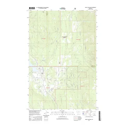
2017 Map of Seeley Lake East
USGS Topo · Published 2017About this map
Seeley Lake and the Clearwater River anchor the southwestern portion of this 2017 survey, where residential development and aviation infrastructure meet the expansive Lolo National Forest. The map documents a dense network of local roads and drives in the settlement of Seeley Lake, such as Mill St, Cedar Ln, and the specifically named School Ln, indicating the community's established footprint.
Find a feature on this map
78 named features on this map. Tap any name to fly to it.
Don’t see what you’re looking for? This feature index may not catch every label — zoom into the map to look around manually.
Map Details
Editions of this 2017 Seeley Lake East Map
This is the sole edition of this map. No revisions or reprints were ever made.
Other maps of this area

1902 · Ovando
USGS Topo · 1:125,000

1905 · Ovando
USGS Topo · 1:125,000

1921 · Elbow Lake
USGS Topo · 1:125,000

1955 · Choteau
USGS Topo · 1:250,000

1957 · Choteau
USGS Topo · 1:250,000

1958 · Choteau
USGS Topo · 1:250,000

1962 · Choteau
USGS Topo · 1:250,000
1965 · Woodworth
USGS Topo · 1:24,000

1965 · Morrell Mountain
USGS Topo · 1:24,000

1965 · Seeley Lake West
USGS Topo · 1:24,000