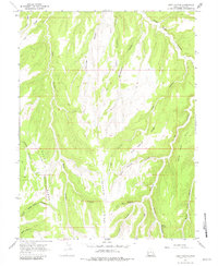
1966 Map of Seep Canyon
USGS Topo · Published 1981About this map
Park Ridge and Monument Ridge dominate this high-plateau landscape in eastern Utah, where the terrain is deeply incised by a complex network of canyons. The map reflects a mid-1960s landscape defined by its hydrography and resource infrastructure, notably the isolated water sources at Seep Spring and Willow Spring. The arrival of industrial utility is evidenced by a prominent Pipeline cutting through the southern portion of Seep Canyon, juxtaposed against older routes like Wagon Road Canyon. This era of the plateau's history shows a transition from traditional land use toward modern energy transport, while the preservation of names such as Cliff Dweller Canyon suggests a long awareness of the area's ancient human presence. A network of Jeep Trails provides the primary access through this remote section of Uintah County, navigating between steep landforms like Trap Ridge and Horse Saddle.
Find a feature on this map
23 named features on this map. Tap any name to fly to it.
Don’t see what you’re looking for? This feature index may not catch every label — zoom into the map to look around manually.
Map Details
Editions of this 1966 Seep Canyon Map
3 editions found
Other maps of this area

1885 · East Tavaputs
USGS Topo · 1:250,000

1956 · Grand Junction
USGS Topo · 1:250,000

1959 · Grand Junction
USGS Topo · 1:250,000

1960 · Grand Junction
USGS Topo · 1:250,000

1962 · Grand Junction
USGS Topo · 1:250,000

1964 · Grand Junction
USGS Topo · 1:250,000

1965 · Grand Junction
USGS Topo · 1:250,000

1966 · Seep Canyon
USGS Topo · 1:24,000

1966 · Bates Knolls
USGS Topo · 1:24,000

1966 · Tom Patterson Canyon
USGS Topo · 1:24,000