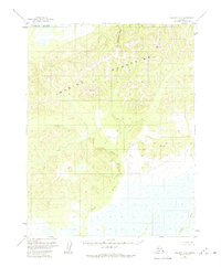
1955 Map of Selawik D-2
USGS Topo · Published 1975About this map
The Waring Mountains dominate this 1950s landscape, providing a dramatic backdrop to the complex hydraulic systems of the Northwest Arctic. This sheet captures a transition between the elevated peaks and the extensive wetlands that define the region's river valleys. The Kobuk River marks the northern edge of the survey, while the southern reaches are characterized by the meandering courses of the Fish River and Ikagoak River. These waterways, along with Eluarnituk Creek, suggest a landscape where seasonal water movement is the primary architect of the terrain. The lack of roads or permanent settlements in this 1955 study emphasizes the area's isolation, where the geography is dictated by the natural flow of water through the mountain foothills and across low-lying basins.
Find a feature on this map
5 named features on this map. Tap any name to fly to it.
Don’t see what you’re looking for? This feature index may not catch every label — zoom into the map to look around manually.
Map Details
Editions of this 1955 Selawik D-2 Map
3 editions found
Other maps of this area

1951 · Baird Mountains
USGS Topo · 1:250,000

1951 · Selawik
USGS Topo · 1:250,000

1955 · Baird Mountains A-1
USGS Topo · 1:63,360

1955 · Selawik D-2
USGS Topo · 1:63,360

1955 · Baird Mountains A-2
USGS Topo · 1:63,360
1955 · Selawik D-1
USGS Topo · 1:63,360

1955 · Selawik C-3
USGS Topo · 1:63,360

1955 · Selawik D-3
USGS Topo · 1:63,360

1955 · Baird Mountains A-3
USGS Topo · 1:63,360

1956 · Baird Mountains
USGS Topo · 1:250,000