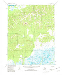
1955 Map of Selawik D-2
USGS Topo · Published 1981About this map
The Waring Mountains dominate this 1955 survey of the Northwest Arctic, where the ridgelines rise between the massive Kobuk River to the north and the expansive wetlands of the south. This remote landscape is defined by its drainage patterns, with Elagantuk Creek cutting through the peaks while the Fish River and Ikagoak River meander through the southern lowlands. These watercourses were historically vital for seasonal travel and subsistence in an area where the map indicates no established roads or trails. Several high points are marked by survey monuments, including VABM 1759 Elwood and VABM 1364 Sam, providing fixed points of reference in an otherwise fluid environment of shifting river channels and seasonal swamps. This 1955 topography, which saw minor revisions in 1981, captures the wilderness character of the region before modern infrastructure development.
Find a feature on this map
8 named features on this map. Tap any name to fly to it.
Don’t see what you’re looking for? This feature index may not catch every label — zoom into the map to look around manually.
Map Details
Editions of this 1955 Selawik D-2 Map
3 editions found
Other maps of this area

1951 · Baird Mountains
USGS Topo · 1:250,000

1951 · Selawik
USGS Topo · 1:250,000

1955 · Baird Mountains A-1
USGS Topo · 1:63,360

1955 · Selawik D-2
USGS Topo · 1:63,360

1955 · Baird Mountains A-2
USGS Topo · 1:63,360
1955 · Selawik D-1
USGS Topo · 1:63,360

1955 · Selawik C-3
USGS Topo · 1:63,360

1955 · Selawik D-3
USGS Topo · 1:63,360

1955 · Baird Mountains A-3
USGS Topo · 1:63,360

1956 · Baird Mountains
USGS Topo · 1:250,000