
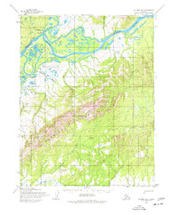
1955 Map of Selawik D-3
USGS Topo · Published 1968About this map
The confluence of the Squirrel River and the Kobuk River anchors this 1955 topographic survey of the Northwest Arctic. The settlement of Kiana is the primary hub of activity, featuring a Landing Strip and small Cabin sites that highlight the reliance on aviation and river transport in this subarctic environment. The landscape is defined by the significant elevation of the Hockley Hills, which dominate the central and southern portions of the quadrangle.
Find a feature on this map
15 named features on this map. Tap any name to fly to it.
Don’t see what you’re looking for? This feature index may not catch every label — zoom into the map to look around manually.
Map Details
Editions of this 1955 Selawik D-3 Map
2 editions found
Other maps of this area

1951 · Baird Mountains
USGS Topo · 1:250,000

1951 · Selawik
USGS Topo · 1:250,000

1955 · Selawik D-2
USGS Topo · 1:63,360

1955 · Baird Mountains A-2
USGS Topo · 1:63,360

1955 · Selawik D-4
USGS Topo · 1:63,360

1955 · Selawik C-3
USGS Topo · 1:63,360

1955 · Selawik C-4
USGS Topo · 1:63,360

1955 · Baird Mountains A-3
USGS Topo · 1:63,360

1955 · Baird Mountains A-4
USGS Topo · 1:63,360

1956 · Baird Mountains
USGS Topo · 1:250,000