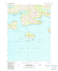
1953 Map of Seldovia A-5
USGS Topo · Published 1988About this map
Portlock and the surrounding coastal reaches of the southern Kenai Peninsula appear in this mid-century survey, highlighting a maritime and industrial landscape at the edge of the Gulf of Alaska. The presence of the Chrome (Aband) mine near Chrome Bay points to the region's history of mineral extraction, while a designated Seaplane Anchorage near Chatham Island underscores the vital role of air transport in this roadless archipelago. The topography is defined by prominent peaks like Cone Mtn and Rock Mtn, which rise sharply above the deep waters of Port Chatham and Chugach Bay. Significant coastal features, including Elizabeth Island and Perl Island, are mapped with precision, showing the intricate network of passages like the Chugach Passage that served as essential routes for local navigation and trade during the 1950s.
Find a feature on this map
22 named features on this map. Tap any name to fly to it.
Don’t see what you’re looking for? This feature index may not catch every label — zoom into the map to look around manually.
Map Details
Editions of this 1953 Seldovia A-5 Map
3 editions found

Other maps of this area

1951 · Seldovia
USGS Topo · 1:250,000

1951 · Seldovia B-5
USGS Topo · 1:63,360

1951 · Seldovia B-4
USGS Topo · 1:63,360

1951 · Seldovia A-6
USGS Topo · 1:63,360

1951 · Seldovia A-4
USGS Topo · 1:63,360

1951 · Seldovia B-6
USGS Topo · 1:63,360

1952 · Afognak
USGS Topo · 1:250,000

1952 · Seldovia A-6
USGS Topo · 1:63,360

1953 · Seldovia B-6
USGS Topo · 1:63,360

1953 · Seldovia B-4
USGS Topo · 1:63,360