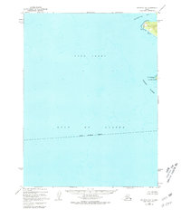
1951 Map of Seldovia A-6
USGS Topo · Published 1981About this map
Cook Inlet and the Gulf of Alaska dominate this maritime survey, illustrating the convergence of major Alaskan waters at the southern tip of the Kenai Peninsula Borough. The landscape is defined by its coastal reaches and submerged bathymetry, featuring the prominent Cape Elizabeth and the adjacent Elizabeth Island. To the north, the protected waters of Koyuktolik Bay provide a distinct contrast to the open sea. While the majority of the sheet covers deep-water soundings, the northeastern corner captures a rugged piece of the Chugach Islands. This 1951 photogrammetric record identifies an area with no roads or trails, documenting the raw shoreline and its offshore hazards before later development or maritime changes.
Find a feature on this map
7 named features on this map. Tap any name to fly to it.
Don’t see what you’re looking for? This feature index may not catch every label — zoom into the map to look around manually.
Map Details
Editions of this 1951 Seldovia A-6 Map
2 editions found
Other maps of this area

1951 · Seldovia
USGS Topo · 1:250,000

1951 · Seldovia B-5
USGS Topo · 1:63,360
1951 · Afognak D-1
USGS Topo · 1:63,360

1951 · Seldovia A-6
USGS Topo · 1:63,360

1951 · Seldovia B-6
USGS Topo · 1:63,360

1952 · Afognak
USGS Topo · 1:250,000

1952 · Seldovia A-6
USGS Topo · 1:63,360

1953 · Seldovia B-6
USGS Topo · 1:63,360

1953 · Seldovia A-5
USGS Topo · 1:63,360

1953 · Seldovia B-5
USGS Topo · 1:63,360