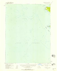
1952 Map of Seldovia A-6
USGS Topo · Published 1958About this map
Cape Elizabeth marks the prominent southwestern tip of the Kenai Peninsula, where the waters of Cook Inlet meet the open Gulf of Alaska. This maritime survey captures the coastal interface during the early 1950s, detailing the soundings and submerged hazards surrounding Elizabeth Island. The topography focuses on the rugged shoreline of the Chugach Islands chain, including the sheltered waters of Koyuktolik Bay. Compiled from USC&GS hydrographic charts and 1951 aerial photography, the map provides a precise record of the shoreline and depth curves at a time when these waters were vital for the region's fishing and maritime transport before major modern developments.
Find a feature on this map
6 named features on this map. Tap any name to fly to it.
Don’t see what you’re looking for? This feature index may not catch every label — zoom into the map to look around manually.
Map Details
Editions of this 1952 Seldovia A-6 Map
2 editions found
Other maps of this area

1951 · Seldovia
USGS Topo · 1:250,000

1951 · Seldovia B-5
USGS Topo · 1:63,360
1951 · Afognak D-1
USGS Topo · 1:63,360

1951 · Seldovia A-6
USGS Topo · 1:63,360

1951 · Seldovia B-6
USGS Topo · 1:63,360

1952 · Afognak
USGS Topo · 1:250,000

1952 · Seldovia A-6
USGS Topo · 1:63,360

1953 · Seldovia B-6
USGS Topo · 1:63,360

1953 · Seldovia A-5
USGS Topo · 1:63,360

1953 · Seldovia B-5
USGS Topo · 1:63,360