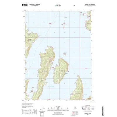
2018 Map of Seward A-3 NW
USGS Topo · Published 2018About this map
The Prince William Sound shoreline and the northern reaches of the Gulf of Alaska define this maritime environment, where the coastal boundary of the Chugach National Forest meets the sea. Central to this map is the mountainous profile of Bainbridge Island, separated from the mainland by the narrow Bainbridge Passage. To the east, Flemming Island and the smaller Gage Island sit within the sound, while the jagged coast of the Kenai Peninsula extends into the western portion of the sheet near Point Countess. The landscape is marked by steep island topography and isolated maritime landmarks such as Sister Rock and the Pleiades Islands. These features illustrate the complex archipelagos and deep-water passages that have historically guided navigation and subsistence in this part of the Alaska coast, providing a clear view of the shoreline before modern developments changed these remote waterways.
Find a feature on this map
25 named features on this map. Tap any name to fly to it.
Don’t see what you’re looking for? This feature index may not catch every label — zoom into the map to look around manually.
Map Details
Editions of this 2018 Seward A-3 NW Map
This is the sole edition of this map. No revisions or reprints were ever made.
Other maps of this area

1950 · Seward B-3
USGS Topo · 1:63,360

1951 · Seward
USGS Topo · 1:250,000

1951 · Seward B-4
USGS Topo · 1:63,360

1951 · Seward A-3
USGS Topo · 1:63,360

1951 · Seward A-4
USGS Topo · 1:63,360

1952 · Seward B-4
USGS Topo · 1:63,360

1952 · Seward A-3
USGS Topo · 1:63,360

1952 · Seward B-3
USGS Topo · 1:63,360

1952 · Seward A-4
USGS Topo · 1:63,360

1953 · Seward
USGS Topo · 1:250,000