
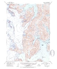
1952 Map of Seward B-4
USGS Topo · Published 1954About this map
Sargent Ice Field dominates the high elevations of this coastal landscape, feeding a massive network of tidewater and alpine glaciers that descend toward Prince William Sound. Large glacial systems including the Princeton Glacier, Chenega Glacier, and the Ultramarine Glacier carve through the mountains of the Chugach National Forest, illustrating the immense ice coverage in the region during the early 1950s. Along the intricate coastline, deep glacial carvings form Blue Fiord, Jackpot Bay, and Nassau Fiord. To the east, the maritime environment is defined by Dangerous Passage and the prominent Chenega Island. This survey captures the relationship between these advancing ice fronts and the surrounding waterways, documenting features like Eshamy Lake and Verdant Island before subsequent decades of significant glacial recession.
Find a feature on this map
23 named features on this map. Tap any name to fly to it.
Don’t see what you’re looking for? This feature index may not catch every label — zoom into the map to look around manually.
Map Details
Editions of this 1952 Seward B-4 Map
2 editions found
Other maps of this area

1950 · Seward B-3
USGS Topo · 1:63,360

1951 · Seward
USGS Topo · 1:250,000

1951 · Seward B-4
USGS Topo · 1:63,360

1951 · Seward C-5
USGS Topo · 1:63,360

1951 · Seward A-5
USGS Topo · 1:63,360

1951 · Seward A-3
USGS Topo · 1:63,360

1951 · Seward B-5
USGS Topo · 1:63,360

1951 · Seward A-4
USGS Topo · 1:63,360

1951 · Seward C-4
USGS Topo · 1:63,360

1951 · Seward C-3
USGS Topo · 1:63,360