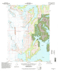
1994 Map of Seward B-4
USGS Topo · Published 1998About this map
Glacial ice and saltwater inlets define this coastal section of the Chugach National Forest, where the massive Princeton Glacier and Chenega Glacier descend toward the sea. The landscape is a complex network of deep water bodies, including the aptly named Blue Fiord and Nassau Fiord, which carve into the mainland. In the east, Chenega Island and Jackpot Island sit along the Dangerous Passage, a waterway that separates the larger islands from the mainland's intricate shoreline. This 1990s revision reveals the inland hydrology where Ewan Lake and Eshamy Lake sit tucked behind coastal peaks like Saddle Peak. The map documents a wilderness without established roads or trails, where the geography is dictated by ice flows like the Nellie Juan Glacier and the Contact Glacier.
Find a feature on this map
24 named features on this map. Tap any name to fly to it.
Don’t see what you’re looking for? This feature index may not catch every label — zoom into the map to look around manually.
Map Details
Editions of this 1994 Seward B-4 Map
This is the sole edition of this map. No revisions or reprints were ever made.
Other maps of this area

1950 · Seward B-3
USGS Topo · 1:63,360

1951 · Seward
USGS Topo · 1:250,000

1951 · Seward B-4
USGS Topo · 1:63,360

1951 · Seward C-5
USGS Topo · 1:63,360

1951 · Seward A-5
USGS Topo · 1:63,360

1951 · Seward A-3
USGS Topo · 1:63,360

1951 · Seward B-5
USGS Topo · 1:63,360

1951 · Seward A-4
USGS Topo · 1:63,360

1951 · Seward C-4
USGS Topo · 1:63,360

1951 · Seward C-3
USGS Topo · 1:63,360