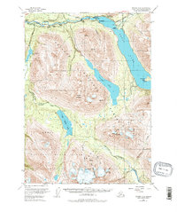
1951 Map of Seward B-8
USGS Topo · Published 1978About this map
Cooper Landing serves as the focal point for this wilderness survey, situated where the Kenai River flows out of the expansive Kenai Lake. The map details a landscape transition during the early 1950s, highlighting a network of small lodges and outposts such as Hentons Lodge, Gwins Lodge, and the Bohan Cabin that supported early tourism and bush travel. The newly established Sterling Highway cuts through the northern corridor, providing modernized access to a region otherwise defined by historic routes like the Resurrection Pass Trail and the Russian River Trail.
Find a feature on this map
43 named features on this map. Tap any name to fly to it.
Don’t see what you’re looking for? This feature index may not catch every label — zoom into the map to look around manually.
Map Details
Editions of this 1951 Seward B-8 Map
4 editions found

Other maps of this area

1944 · Kenai
USGS Topo · 1:250,000

1950 · Kenai
USGS Topo · 1:250,000

1950 · Kenai B-1
USGS Topo · 1:63,360

1950 · Seward A-8
USGS Topo · 1:63,360

1950 · Seward A-7
USGS Topo · 1:63,360

1951 · Seward
USGS Topo · 1:250,000

1951 · Seward A-7
USGS Topo · 1:63,360

1951 · Kenai C-1
USGS Topo · 1:63,360

1951 · Seward B-7
USGS Topo · 1:63,360

1951 · Kenai A-1
USGS Topo · 1:63,360