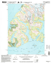
1995 Map of Seward D-3
USGS Topo · Published 1999About this map
Glacial landscapes and marine industry converge on Esther Island within the Chugach National Forest. The map documents the northern reaches of Prince William Sound, where the Crescent Glacier, Tommy Glacier, and Cap Glacier dominate the high terrain above Port Wells. Coastal activity is concentrated around Esther Passage and the southern shore, featuring a Fish Hatchery (Pvt) and Oyster Farm (Pvt) near Eaglek Bay. The presence of the Golden (Site) on the northern coast points to earlier settlement history in this remote area. Navigational aids like the Point Esther Light and the routes of the Alaska Marine Highway illustrate how the region remained connected by water rather than roads, serving as a corridor between Wells Passage and the surrounding wilderness areas of Granite Bay State Marine Park.
Find a feature on this map
45 named features on this map. Tap any name to fly to it.
Don’t see what you’re looking for? This feature index may not catch every label — zoom into the map to look around manually.
Map Details
Editions of this 1995 Seward D-3 Map
This is the sole edition of this map. No revisions or reprints were ever made.
Other maps of this area

1951 · Seward
USGS Topo · 1:250,000

1951 · Anchorage
USGS Topo · 1:250,000

1951 · Seward D-2
USGS Topo · 1:63,360

1951 · Seward D-4
USGS Topo · 1:63,360

1951 · Seward D-3
USGS Topo · 1:63,360

1951 · Seward C-4
USGS Topo · 1:63,360

1951 · Seward C-3
USGS Topo · 1:63,360

1951 · Seward C-2
USGS Topo · 1:63,360

1952 · Seward D-3
USGS Topo · 1:63,360

1952 · Seward C-3
USGS Topo · 1:63,360