
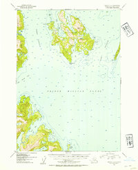
1952 Map of Seward C-3
USGS Topo · Published 1954About this map
Perry Island and its surrounding waters dominate this maritime survey of Prince William Sound, where several small Cabins and a Lighthouse Reserve mark the sparse human footprint in the Chugach National Forest. The complex coastline of the island is defined by deep inlets like West Twin Bay and South Bay, which provided sheltered anchorage for coastal navigators in the early 1950s. To the west, the narrow Perry Passage separates the main landmass from Culross Island. Further south, the map illustrates the glacial topography of the mainland, characterized by Main Bay and the drainage of Falls Lake into Falls Bay. This survey captures the remote character of the sound during a period of active hydrographic study, showing soundings across Port Nellie Juan and Lone Passage.
Find a feature on this map
25 named features on this map. Tap any name to fly to it.
Don’t see what you’re looking for? This feature index may not catch every label — zoom into the map to look around manually.
Map Details
Editions of this 1952 Seward C-3 Map
2 editions found
Other maps of this area

1950 · Seward B-3
USGS Topo · 1:63,360

1951 · Seward
USGS Topo · 1:250,000

1951 · Seward B-4
USGS Topo · 1:63,360

1951 · Seward D-2
USGS Topo · 1:63,360

1951 · Seward D-4
USGS Topo · 1:63,360

1951 · Seward B-2
USGS Topo · 1:63,360

1951 · Seward D-3
USGS Topo · 1:63,360

1951 · Seward C-4
USGS Topo · 1:63,360

1951 · Seward C-3
USGS Topo · 1:63,360

1951 · Seward C-2
USGS Topo · 1:63,360