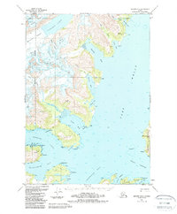
1951 Map of Seward D-4
USGS Topo · Published 1988About this map
The glacier-carved coastline of the Chugach National Forest is the defining characteristic of this coastal Alaska region. Dramatic ice flows like Roaring Glacier, Dirty Glacier, and Bettles Glacier descend into the deep waters of Harriman Fiord, while human industry appears in small pockets along the shore. Remote mineral sites such as Granite Mine near Hobo Bay and Lansing Mine further south point to the area's prospecting history. Navigation markers, including the Pt Pigot Light, guide travel between Passage Canal and Port Wells. Local activity is grounded in sheltered waters like Logging Camp Bay and Pirate Cove, providing essential anchorage within the larger network of Cochrane Bay and Blackstone Bay.
Find a feature on this map
46 named features on this map. Tap any name to fly to it.
Don’t see what you’re looking for? This feature index may not catch every label — zoom into the map to look around manually.
Map Details
Editions of this 1951 Seward D-4 Map
5 editions found
Other maps of this area

1951 · Seward
USGS Topo · 1:250,000

1951 · Anchorage
USGS Topo · 1:250,000

1951 · Seward D-5
USGS Topo · 1:63,360

1951 · Seward C-5
USGS Topo · 1:63,360

1951 · Seward D-4
USGS Topo · 1:63,360

1951 · Seward D-3
USGS Topo · 1:63,360

1951 · Seward C-4
USGS Topo · 1:63,360

1951 · Seward C-3
USGS Topo · 1:63,360

1952 · Seward D-5
USGS Topo · 1:63,360

1952 · Seward D-3
USGS Topo · 1:63,360