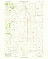
1971 Map of Shabbona Grove
USGS Topo · Published 1973About this map
Shabbona Grove sits at the northern edge of this agricultural landscape, where the prairie of the DeKalb and La Salle county line is dissected by the meandering path of Indian Creek. In the early 1970s, the region's economy is clearly defined by its geometric road network, including Shabbona Grove Road and Suydam Road, and the infrastructure of the Chicago and North Western railroad.
Find a feature on this map
25 named features on this map. Tap any name to fly to it.
Don’t see what you’re looking for? This feature index may not catch every label — zoom into the map to look around manually.
Map Details
Editions of this 1971 Shabbona Grove Map
2 editions found
Other maps of this area

1934 · De Kalb
USGS Topo · 1:62,500

1937 · De Kalb
USGS Topo · 1:62,500

1937 · Sycamore
USGS Topo · 1:62,500

1948 · Sandwich
USGS Topo · 1:62,500

1950 · Sandwich
USGS Topo · 1:62,500

1951 · Earlville
USGS Topo · 1:62,500

1958 · Aurora
USGS Topo · 1:250,000

1961 · Aurora
USGS Topo · 1:250,000
1968 · Hinckley
USGS Topo · 1:24,000
1971 · Leland
USGS Topo · 1:24,000