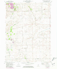
1971 Map of Shabbona Grove
USGS Topo · Published 1981About this map
Shabbona Lake State Park and the adjacent Shabbona Lake anchor the northern landscape of this agricultural region where DeKalb and La Salle Counties meet. The rural settlement of Shabbona Grove sits at a crossroads near the Chicago and North Western rail line, serving as a focal point for the surrounding townships of Paw Paw and Victor. The map reveals a deeply rooted farming community, evidenced by several family-named landmarks and country burial grounds like Johnson Grove Cem, Victor Cem, and Stevens Cem. Waterways including Little Indian Creek and Indian Creek wind through the township sections, occasionally carving features like the notably named Sleepy Hollow. The grid of secondary roads, such as Suydam Road and Wesson Road, connects numerous small farmsteads and active Gravel Pits, illustrating the local infrastructure at the start of the 1970s.
Find a feature on this map
28 named features on this map. Tap any name to fly to it.
Don’t see what you’re looking for? This feature index may not catch every label — zoom into the map to look around manually.
Map Details
Editions of this 1971 Shabbona Grove Map
2 editions found
Other maps of this area

1934 · De Kalb
USGS Topo · 1:62,500

1937 · De Kalb
USGS Topo · 1:62,500

1937 · Sycamore
USGS Topo · 1:62,500

1948 · Sandwich
USGS Topo · 1:62,500

1950 · Sandwich
USGS Topo · 1:62,500

1951 · Earlville
USGS Topo · 1:62,500

1958 · Aurora
USGS Topo · 1:250,000

1961 · Aurora
USGS Topo · 1:250,000
1968 · Hinckley
USGS Topo · 1:24,000
1971 · Leland
USGS Topo · 1:24,000