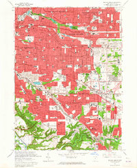
1963 Map of Shaker Heights
USGS Topo · Published 1965About this map
Shaker Heights and its neighboring eastern suburbs in the early 1960s reveal a landscape of planned residential expansion and significant institutional footprints. The map highlights the sophisticated hydrological and park system of the era, centered on Upper Shaker Lake and Lower Shaker Lake, while the Rapid Transit lines underscore the region's commitment to commuter infrastructure. Large-scale public works like the Baldwin Reservoir and the expansive Bedford Reservation define the greenbelts between burgeoning developments.
Find a feature on this map
105 named features on this map. Tap any name to fly to it.
Don’t see what you’re looking for? This feature index may not catch every label — zoom into the map to look around manually.
Map Details
Editions of this 1963 Shaker Heights Map
4 editions found
Other maps of this area

1901 · Euclid
USGS Topo · 1:62,500

1903 · Cleveland
USGS Topo · 1:62,500

1903 · Euclid
USGS Topo · 1:62,500

1905 · Mentor
USGS Topo · 1:62,500

1906 · Chagrin Falls
USGS Topo · 1:62,500

1907 · Mentor
USGS Topo · 1:62,500

1908 · Chagrin Falls
USGS Topo · 1:62,500

1950 · Cleveland
USGS Topo · 1:250,000

1953 · Chagrin Falls
USGS Topo · 1:24,000

1953 · Shaker Heights
USGS Topo · 1:24,000