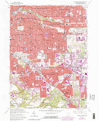
1963 Map of Shaker Heights
USGS Topo · Published 1980About this map
The eastern suburbs of Cleveland are captured here during a period of rapid post-war expansion and urban infill. This 1963 survey, with later revisions showing the growth of Warrensville Heights and Bedford Heights, illustrates the dense grid of residential streets and essential community institutions like Benedictine High Sch and St Lukes Hospital. The landscape is a mix of established neighborhoods and large institutional footprints, including the Cleveland House of Correction and the Thistledown Racetrack.
Find a feature on this map
77 named features on this map. Tap any name to fly to it.
Don’t see what you’re looking for? This feature index may not catch every label — zoom into the map to look around manually.
Map Details
Editions of this 1963 Shaker Heights Map
4 editions found
Other maps of this area

1901 · Euclid
USGS Topo · 1:62,500

1903 · Cleveland
USGS Topo · 1:62,500

1903 · Euclid
USGS Topo · 1:62,500

1905 · Mentor
USGS Topo · 1:62,500

1906 · Chagrin Falls
USGS Topo · 1:62,500

1907 · Mentor
USGS Topo · 1:62,500

1908 · Chagrin Falls
USGS Topo · 1:62,500

1950 · Cleveland
USGS Topo · 1:250,000

1953 · Chagrin Falls
USGS Topo · 1:24,000

1953 · Shaker Heights
USGS Topo · 1:24,000