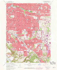
1963 Map of Shaker Heights
USGS Topo · Published 1971About this map
Cleveland Heights and the surrounding eastern suburbs show a landscape defined by rapid mid-century expansion and established civic institutions. The intricate residential networks of Shaker Heights and University Heights are punctuated by numerous parochial and public schools, including Benedictine High Sch and Woodbury Jr High Sch. The topography is shaped by water features like Lower Shaker Lake and Upper Shaker Lake, while the expansive grounds of Calvary Cemetery and Highland Park Cemetery provide significant landmarks for local history. Transport corridors like the Rapid Transit lines and the Penn Central tracks highlight the region's connection to the urban core. Further south, the suburban commercial shift is evident at the Southgate Shopping Center and recreational sites like the Thistledown Racetrack in North Randall.
Find a feature on this map
129 named features on this map. Tap any name to fly to it.
Don’t see what you’re looking for? This feature index may not catch every label — zoom into the map to look around manually.
Map Details
Editions of this 1963 Shaker Heights Map
4 editions found
Other maps of this area

1901 · Euclid
USGS Topo · 1:62,500

1903 · Cleveland
USGS Topo · 1:62,500

1903 · Euclid
USGS Topo · 1:62,500

1905 · Mentor
USGS Topo · 1:62,500

1906 · Chagrin Falls
USGS Topo · 1:62,500

1907 · Mentor
USGS Topo · 1:62,500

1908 · Chagrin Falls
USGS Topo · 1:62,500

1950 · Cleveland
USGS Topo · 1:250,000

1953 · Chagrin Falls
USGS Topo · 1:24,000

1953 · Shaker Heights
USGS Topo · 1:24,000