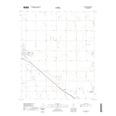
2019 Map of Shallowater
USGS Topo · Published 2019About this map
Shallowater and the outlying community of Broadview anchor this High Plains landscape, where the traditional agricultural grid meets the northwestern expansion of Lubbock. The map reveals a transition from rural sections to the emerging suburban fringes of the city, characterized by the diagonal path of Clovis Rd (U.S. Highway 84). The terrain is subtly marked by the ephemeral hydrology of the Southern High Plains, with the northern reaches containing Blackwater Draw and the southern portion featuring Yellow House Draw. These natural depressions contrast with the rigid layout of farm-to-market roads like FM 1729 and FM 1294, illustrating how the region's transport network was engineered across the flat Llano Estacado. Local researchers will find the municipal core of Shallowater clearly defined, complete with its Post Office and a dense residential grid of streets such as Drew St and numbered avenues.
Find a feature on this map
47 named features on this map. Tap any name to fly to it.
Don’t see what you’re looking for? This feature index may not catch every label — zoom into the map to look around manually.
Map Details
Editions of this 2019 Shallowater Map
This is the sole edition of this map. No revisions or reprints were ever made.
Other maps of this area

1954 · Lubbock
USGS Topo · 1:250,000

1954 · Brownfield
USGS Topo · 1:250,000

1956 · Shallowater
USGS Topo · 1:24,000

1956 · New Deal
USGS Topo · 1:24,000

1957 · Lubbock East
USGS Topo · 1:24,000

1957 · Lubbock West
USGS Topo · 1:24,000

1957 · Lubbock
USGS Topo · 1:62,500

1957 · Anton
USGS Topo · 1:62,500

1957 · Abernathy
USGS Topo · 1:62,500

1957 · Wolfforth
USGS Topo · 1:62,500