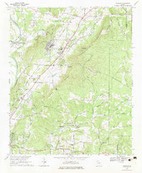
1968 Map of Shannon
USGS Topo · Published 1983About this map
The Southern Railway corridor anchors this portion of Floyd and Bartow Counties, driving the development of Shannon and the nearby Model High Sch. Industrial and utility infrastructure is prominent near the rail line, including a Filtration Plant and Sewage Disposal facility, while the surrounding landscape transitions into the steep slopes of Armuchee Mountain. To the east, the Hermitage Lookout Tower and a Fire Tower overlook a network of rural roads like East Hermitage Road and Barnstley Gardens Road. Local history is reflected in numerous country churches and burial grounds, such as Big Pleasant Grove Cem and Rush Chapel. Along the western edge, the Oostanaula River snakes past the Northwest Georgia Experimental Station, illustrating the region's mix of agricultural research, industrial utility, and scattered residential pockets like Sherwood Forest.
Find a feature on this map
73 named features on this map. Tap any name to fly to it.
Don’t see what you’re looking for? This feature index may not catch every label — zoom into the map to look around manually.
Map Details
Editions of this 1968 Shannon Map
4 editions found
Other maps of this area

1886 · Rome
USGS Topo · 1:125,000

1890 · Cartersville
USGS Topo · 1:125,000

1891 · Cartersville
USGS Topo · 1:125,000

1896 · Cartersville
USGS Topo · 1:125,000

1898 · Rome
USGS Topo · 1:125,000

1899 · Rome
USGS Topo · 1:125,000

1904 · Rome
USGS Topo · 1:125,000

1906 · Stilesboro
USGS Topo · 1:62,500

1908 · Stilesboro
USGS Topo · 1:62,500

1941 · Adairsville
USGS Topo · 1:62,500