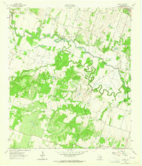
1963 Map of Sharp
USGS Topo · Published 1964About this map
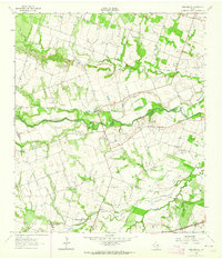
Buckholts stands at the northern edge of this Milam County landscape, where the GC & SF railroad cuts through the terrain. The area is defined by the winding course of the Little River, which creates a complex hydrology of oxbows and secondary channels like Cutoff Slough. This mid-century survey reveals a rural society organized around small community hubs, evidenced by numerous country churches such as Liveoak Ch and Friendship Ch, and the Hall Sch. Genealogists will find significant value in the distribution of family and community burial grounds, including the Bryant Station Cem and Lewis Cem. The map also documents localized industrial and infrastructure markers, from the numerous Gravel Pits to the Landing Strip and the historic Cummins Crossing, offering a clear view of the Texas interior before modern consolidation changed the rural character.
Find a feature on this map
34 named features on this map. Tap any name to fly to it.
Don’t see what you’re looking for? This feature index may not catch every label — zoom into the map to look around manually.
Map Details
Editions of this 1963 Sharp Map
3 editions found
Other maps of this area

1885 · Taylor
USGS Topo · 1:125,000

1887 · Taylor
USGS Topo · 1:125,000

1894 · Taylor
USGS Topo · 1:125,000

1910 · Buckholts
USGS Topo · 1:24,000

1912 · Buckholts
USGS Topo · 1:31,680

1954 · Austin
USGS Topo · 1:250,000

1962 · Rockdale West
USGS Topo · 1:24,000
1962 · Pettibone
USGS Topo · 1:24,000

1963 · Friendship
USGS Topo · 1:24,000
1963 · San Gabriel
USGS Topo · 1:24,000