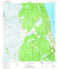
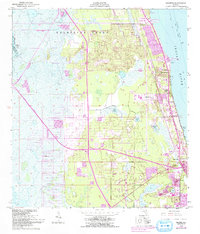
1949 Map of Sharpes
USGS Topo · Published 1966About this map
The Delespine Grant dominates this coastal landscape, reflecting the long history of land grants in Florida that persisted well into the mid-20th century. Following the western bank of the Indian River, the Florida East Coast railway serves as the primary corridor for development, linking small waterfront communities like Frontenac, Sharpes, and City Point. This transit-oriented settlement pattern is typical of the pre-interstate era, where life and commerce centered on the rail line and the Intracoastal Waterway. Landmarks such as the Airway Beacon 19 (C) and Pinkerton Pier (C) point to the region's importance for both aviation navigation and maritime trade. Further inland, the terrain transitions into a complex of wetlands and smaller bodies of water, including Lake Wilson and Geiger Lake, showcasing the undeveloped character of Brevard County before the massive infrastructure projects of the later space-age boom.
Find a feature on this map
21 named features on this map. Tap any name to fly to it.
Don’t see what you’re looking for? This feature index may not catch every label — zoom into the map to look around manually.
Map Details
Editions of this 1949 Sharpes Map
6 editions found
Other maps of this area

1949 · Orsino
USGS Topo · 1:24,000

1949 · Titusville
USGS Topo · 1:24,000

1949 · Courtenay
USGS Topo · 1:24,000

1949 · Sharpes
USGS Topo · 1:24,000

1949 · Cocoa
USGS Topo · 1:24,000

1951 · Cocoa
USGS Topo · 1:24,000

1951 · Courtenay
USGS Topo · 1:24,000

1951 · Sharpes
USGS Topo · 1:24,000

1951 · Orsino
USGS Topo · 1:24,000

1952 · Titusville
USGS Topo · 1:24,000