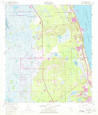
1949 Map of Sharpes
USGS Topo · Published 1972About this map
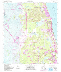
Delespine Grant dominates the northern landscape of this coastal region, where mid-century growth begins to bridge the gap between historic settlements and modern infrastructure. The Florida East Coast corridor serves as the primary artery for the area, threading through a string of riverside communities including Frontenac, Sharpes, and City Point. The 1970 revisions, marked in purple, illustrate the suburban expansion pushing westward from the Indian River shoreline, encroaching upon the marshy interior near Lake Wilson and Sharpes Lake. Along the waterfront, specialized landmarks like the Pinkerton Pier (C) and a Drive-in Theater reflect the era's commercial and recreational footprint. The map also captures industrial development in the form of a Powerplant and Substation near Jones Pt, positioned to serve the burgeoning population of Brevard and Orange Counties.
Find a feature on this map
24 named features on this map. Tap any name to fly to it.
Don’t see what you’re looking for? This feature index may not catch every label — zoom into the map to look around manually.
Map Details
Editions of this 1949 Sharpes Map
6 editions found
Other maps of this area

1949 · Orsino
USGS Topo · 1:24,000

1949 · Titusville
USGS Topo · 1:24,000

1949 · Courtenay
USGS Topo · 1:24,000

1949 · Sharpes
USGS Topo · 1:24,000

1949 · Cocoa
USGS Topo · 1:24,000

1951 · Cocoa
USGS Topo · 1:24,000

1951 · Courtenay
USGS Topo · 1:24,000

1951 · Sharpes
USGS Topo · 1:24,000

1951 · Orsino
USGS Topo · 1:24,000

1952 · Titusville
USGS Topo · 1:24,000