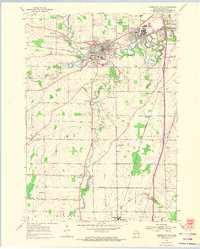
1954 Map of Sheboygan Falls
USGS Topo · Published 1974About this map
The Sheboygan River and Onion River converge near the heart of this mid-century Wisconsin landscape, anchoring a region of well-established dairy farms and industrial villages. In the town of Sheboygan Falls, the river's path is marked by early infrastructure like the Water Tank and Sewage Disposal plant, while the planned community of Kohler showcases its distinct residential and industrial layout. The map documents a dense network of rural civic life, from the Lima Center Sch and Hillcrest Sch to the numerous family and parish burial grounds such as Jansen Cem and Flader Cem. These features, along with the Chicago and North Western rail lines, illustrate the 1950s transition as rural crossroads like Ourtown and Gibbsville remained vital centers for the surrounding townships of Lima, Wilson, and Holland.
Find a feature on this map
37 named features on this map. Tap any name to fly to it.
Don’t see what you’re looking for? This feature index may not catch every label — zoom into the map to look around manually.
Map Details
Editions of this 1954 Sheboygan Falls Map
3 editions found
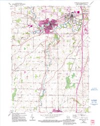
Other maps of this area

1954 · Sheboygan Falls
USGS Topo · 1:62,500

1954 · Sheboygan South
USGS Topo · 1:62,500

1954 · Sheboygan Falls
USGS Topo · 1:24,000

1954 · Sheboygan North
USGS Topo · 1:62,500

1954 · Sheboygan North
USGS Topo · 1:24,000

1954 · Sheboygan South
USGS Topo · 1:24,000

1954 · Howards Grove
USGS Topo · 1:62,500

1954 · Howards Grove
USGS Topo · 1:24,000

1954 · Franklin
USGS Topo · 1:24,000

1954 · Milwaukee
USGS Topo · 1:250,000