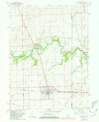
1964 Map of Sheldon
USGS Topo · Published 1981About this map
Sheldon and Iroquois anchor this agricultural landscape along the state line, where the prairie is defined by an extensive drainage network and the convergence of major rail lines. The Chicago Milwaukee St Paul and Pacific and the Toledo Peoria and Western railroads intersect near the center of the survey, marking the area’s importance as a transportation corridor. Flowing through the center, the Iroquois River is supported by a system of man-made channels such as Baird Ditch and Eastburn Ditch No 1, which facilitated the cultivation of the fertile flatlands. Local history is preserved in several small landmarks, including the Morris Chapel and multiple family-named burial sites like Gaffield Cem and Liberty Cem. The eastern edge of the map highlights the border with Indiana, where the village of Effner sits directly on the boundary line.
Find a feature on this map
46 named features on this map. Tap any name to fly to it.
Don’t see what you’re looking for? This feature index may not catch every label — zoom into the map to look around manually.
Map Details
Editions of this 1964 Sheldon Map
Other maps of this area

1935 · Watseka
USGS Topo · 1:48,000

1938 · Milford
USGS Topo · 1:48,000

1939 · Watseka
USGS Topo · 1:62,500

1944 · Milford
USGS Topo · 1:62,500

1953 · Danville
USGS Topo · 1:250,000

1955 · Danville
USGS Topo · 1:250,000

1956 · Danville
USGS Topo · 1:250,000

1961 · Kentland
USGS Topo · 1:24,000

1961 · Morocco
USGS Topo · 1:24,000

1962 · Earl Park
USGS Topo · 1:24,000