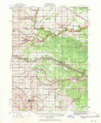
1930 Map of Shepherd
USGS Topo · Published 1971About this map
The village of Shepherd serves as a primary hub in this central Michigan landscape during the late 1920s, situated at the intersection of the Ann Arbor railroad and a grid of rural country roads. To the north and east, the Chippewa River and Salt River systems wind through the terrain, supporting several smaller settlements like Oil City and Delwin. This era is defined by an incredibly dense network of one-room schoolhouses, such as Alembic Sch, Polish Sch, and Root Sch, which illustrate the localized nature of rural education before modern consolidation.
Find a feature on this map
70 named features on this map. Tap any name to fly to it.
Don’t see what you’re looking for? This feature index may not catch every label — zoom into the map to look around manually.
Map Details
Editions of this 1930 Shepherd Map
3 editions found
Other maps of this area

1916 · Mount Pleasant
USGS Topo · 1:62,500

1919 · Mount Pleasant
USGS Topo · 1:62,500

1930 · Shepherd
USGS Topo · 1:48,000

1934 · Sanford
USGS Topo · 1:62,500

1934 · Merrill
USGS Topo · 1:62,500

1935 · Alma
USGS Topo · 1:62,500

1936 · Shepherd
USGS Topo · 1:62,500

1936 · Sanford
USGS Topo · 1:62,500

1937 · Merrill
USGS Topo · 1:62,500

1938 · Alma
USGS Topo · 1:62,500