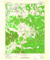
1962 Map of Shepherdsville
USGS Topo · Published 1964About this map
Shepherdsville serves as a central hub on this Bullitt County landscape, situated along the banks of the Salt River just as the mid-century transportation network was evolving. The coexistence of the Louisville and Nashville railroad and the Kentucky Turnpike illustrates a transition in regional commerce and travel, while the extensive acreage of the Bernheim Forest preserves a significant portion of the knobs region to the southeast. Family history is well-represented through numerous burial sites such as Hall Cem, Shelton Cem, and Cundiff Cem, alongside local landmarks like Roby Sch and Vine Hill Ch. The southern portion of the sheet reaches the edge of the Fort Knox Military Reservation, while smaller settlements like Clermont, Belmont, and Bardstown Junction follow the rail corridor, marking the established path of 19th and early 20th-century growth.
Find a feature on this map
53 named features on this map. Tap any name to fly to it.
Don’t see what you’re looking for? This feature index may not catch every label — zoom into the map to look around manually.
Map Details
Editions of this 1962 Shepherdsville Map
3 editions found
Other maps of this area

1907 · Louisville
USGS Topo · 1:62,500

1909 · Kosmosdale
USGS Topo · 1:48,000

1912 · Kosmosdale
USGS Topo · 1:62,500

1936 · Vine Grove
USGS Topo · 1:62,500

1943 · Vine Grove
USGS Topo · 1:62,500

1946 · Pitts Point
USGS Topo · 1:24,000

1946 · Colesburg
USGS Topo · 1:24,000

1946 · Vine Grove
USGS Topo · 1:62,500

1949 · Cravens
USGS Topo · 1:24,000

1949 · Shepherdsville
USGS Topo · 1:24,000