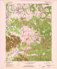
1962 Map of Shepherdsville
USGS Topo · Published 1972About this map
Shepherdsville and the surrounding Bullitt County landscape are defined by the winding course of the Salt River and the significant rail corridor of the Louisville and Nashville. This 1962 revision captures a region in transition, where the Kentucky Turnpike and its various interchanges begin to reshape the traditional settlement patterns of places like Bardstown Junction and Belmont. To the south and east, the map reveals the extensive protected lands of Bernheim Forest, featuring Lake Nevin and several smaller bodies of water like Cedar Lakes. Local heritage is preserved in the numerous family and community burial grounds, including Hill Cem and Smith Cem, and small rural landmarks like Vine Hill Ch. The presence of the Fort Knox Military Reservation boundary in the southwest corner marks the edge of the large federal installation during the Cold War era.
Find a feature on this map
48 named features on this map. Tap any name to fly to it.
Don’t see what you’re looking for? This feature index may not catch every label — zoom into the map to look around manually.
Map Details
Editions of this 1962 Shepherdsville Map
3 editions found
Other maps of this area

1907 · Louisville
USGS Topo · 1:62,500

1909 · Kosmosdale
USGS Topo · 1:48,000

1912 · Kosmosdale
USGS Topo · 1:62,500

1936 · Vine Grove
USGS Topo · 1:62,500

1943 · Vine Grove
USGS Topo · 1:62,500

1946 · Pitts Point
USGS Topo · 1:24,000

1946 · Colesburg
USGS Topo · 1:24,000

1946 · Vine Grove
USGS Topo · 1:62,500

1949 · Cravens
USGS Topo · 1:24,000

1949 · Shepherdsville
USGS Topo · 1:24,000