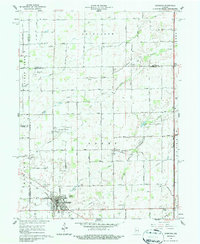
1961 Map of Sheridan
USGS Topo · Published 1987About this map
Sheridan anchors this agricultural region at the junction of Hamilton and Boone Counties, serving as a hub for the surrounding township of Adams. The local economy of the early 1960s is defined by the Monon railroad line cutting through the town center and the presence of the Gravel Pit and Sewage Disposal infrastructure. Aviation is represented by both Black Hawk Airport and the Sheridan Airport, highlighting a period of increasing local air travel.
Find a feature on this map
77 named features on this map. Tap any name to fly to it.
Don’t see what you’re looking for? This feature index may not catch every label — zoom into the map to look around manually.
Map Details
Editions of this 1961 Sheridan Map
3 editions found
Other maps of this area

1953 · Westfield
USGS Topo · 1:24,000

1953 · Rosston
USGS Topo · 1:24,000

1953 · Noblesville
USGS Topo · 1:24,000

1953 · Danville
USGS Topo · 1:250,000

1955 · Danville
USGS Topo · 1:250,000

1956 · Danville
USGS Topo · 1:250,000

1960 · Noblesville
USGS Topo · 1:24,000

1960 · Kempton
USGS Topo · 1:24,000

1960 · Tipton
USGS Topo · 1:24,000

1961 · Sheridan
USGS Topo · 1:24,000