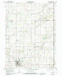
1961 Map of Sheridan
USGS Topo · Published 1992About this map
Sheridan serves as the primary hub of this agricultural landscape in northern Hamilton County, situated at the junction of several key drainage systems. The town layout is clearly defined, featuring industrial elements like a Sewage Disposal plant and Gravel Pit, alongside community spaces such as Legion Park. The surrounding townships of Adams, Jackson, and Jefferson are characterized by an intricate network of man-made waterways, including Boyer Ditch and Mallott Ditch, which were essential for reclaiming the fertile soil for farming. Family history is etched across the township lines through numerous small burial grounds like Teter Cem, Phillips Cem, and the larger Crown Hill Cem. Beyond the main settlement, smaller communities such as Boxley, Ekin, and Bakers Corner provide secondary anchors for rural life. Small-scale aviation is represented by both Black Hawk Airport and the Sheridan Airport, illustrating the evolving transportation needs of the mid-20th century.
Find a feature on this map
59 named features on this map. Tap any name to fly to it.
Don’t see what you’re looking for? This feature index may not catch every label — zoom into the map to look around manually.
Map Details
Editions of this 1961 Sheridan Map
3 editions found
Other maps of this area

1953 · Westfield
USGS Topo · 1:24,000

1953 · Rosston
USGS Topo · 1:24,000

1953 · Noblesville
USGS Topo · 1:24,000

1953 · Danville
USGS Topo · 1:250,000

1955 · Danville
USGS Topo · 1:250,000

1956 · Danville
USGS Topo · 1:250,000

1960 · Noblesville
USGS Topo · 1:24,000

1960 · Kempton
USGS Topo · 1:24,000

1960 · Tipton
USGS Topo · 1:24,000

1961 · Sheridan
USGS Topo · 1:24,000