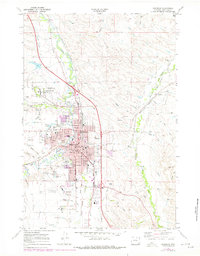
1968 Map of Sheridan
USGS Topo · Published 1978About this map
Sheridan is shown here as a thriving regional hub in the late 1960s, defined by its complex irrigation network and position along the Burlington Northern railroad. The map highlights significant public institutions, including the sprawling Veterans Adm Hospital and the Sheridan Jr College campus. The city's residential and civic footprint, including the Courthouse and several local schools like Linden Sch, is surrounded by a landscape dedicated to water management and industry. Numerous man-made waterways like the Burlington Ditch and Grinnell Livestock Company Ditch crisscross the area, feeding from Goose Creek. To the south, the County Airport and the State Girls Sch mark the edge of town before the terrain transitions into the draws and gulches of the Wyoming high plains, such as Chapek Draw and Hunter Draw.
Find a feature on this map
55 named features on this map. Tap any name to fly to it.
Don’t see what you’re looking for? This feature index may not catch every label — zoom into the map to look around manually.
Map Details
Editions of this 1968 Sheridan Map
3 editions found
Other maps of this area

1895 · Dayton
USGS Topo · 1:125,000

1901 · Dayton
USGS Topo · 1:125,000

1909 · Sheridan
USGS Topo · 1:125,000

1911 · Sheridan
USGS Topo · 1:125,000

1955 · Sheridan
USGS Topo · 1:250,000

1958 · Sheridan
USGS Topo · 1:250,000

1962 · Sheridan
USGS Topo · 1:250,000
1964 · Monarch
USGS Topo · 1:24,000
1964 · Hultz Draw
USGS Topo · 1:24,000
1964 · Beaver Creek Hills
USGS Topo · 1:24,000