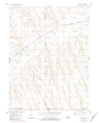
1957 Map of Shippee
USGS Topo · Published 1983About this map
Beaver Creek meanders through the central valley of this landscape, carving a path through the Nebraska-Kansas borderlands. The small settlement of Shippee sits at a critical intersection where the Burlington Northern railroad lines align with the valley floor, reflecting the traditional reliance on rail for transporting agricultural goods from this border region. The terrain is defined by the high divides between the Beaver and Johnson Creek watersheds, which cross several county lines including the borders of Red Willow, Furnas, and Decatur counties. For genealogists, the Tyrolte Cem near the northern map edge serves as a significant marker of early local families who settled along these high plains before the mid-century revisions were documented.
Find a feature on this map
9 named features on this map. Tap any name to fly to it.
Don’t see what you’re looking for? This feature index may not catch every label — zoom into the map to look around manually.
Map Details
Editions of this 1957 Shippee Map
2 editions found
Other maps of this area

1951 · Norcatur
USGS Topo · 1:62,500

1951 · Kanona
USGS Topo · 1:62,500

1954 · McCook
USGS Topo · 1:250,000

1954 · Goodland
USGS Topo · 1:250,000

1956 · Goodland
USGS Topo · 1:250,000

1957 · McCook
USGS Topo · 1:250,000

1957 · Goodland
USGS Topo · 1:250,000

1957 · Shippee
USGS Topo · 1:24,000
1957 · Wilsonville
USGS Topo · 1:24,000

1957 · Lebanon
USGS Topo · 1:24,000