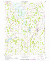
1961 Map of Shreve
USGS Topo · Published 1978About this map
The village of Shreve serves as the focal point of this region at the intersection of Clinton and Washington townships. The landscape is characterized by a mix of agricultural fields and wetland areas, notably the Shreve Lake Wildlife Area and the glacial remnants of Odell Lake and Brown Lake. This 1961 survey, later updated in 1978, documents a rural economy transitioning as industrial infrastructure like the Pennsylvania railroad and multiple pipelines cross the terrain. For genealogists, the map preserves the locations of numerous country congregations and burying grounds, including Maple Grove Ch, Newkirk Ch, and the Bigelow Ch Cem in the southern hills. The presence of an Old Railroad Grade north of Craigton provides a specific look at the changing transportation corridors of the mid-20th century.
Find a feature on this map
35 named features on this map. Tap any name to fly to it.
Don’t see what you’re looking for? This feature index may not catch every label — zoom into the map to look around manually.
Map Details
Editions of this 1961 Shreve Map
3 editions found
Other maps of this area

1901 · Wooster
USGS Topo · 1:62,500

1903 · Wooster
USGS Topo · 1:62,500

1906 · West Salem
USGS Topo · 1:62,500

1908 · West Salem
USGS Topo · 1:62,500

1912 · Loudonville
USGS Topo · 1:62,500

1914 · Loudonville
USGS Topo · 1:62,500

1915 · Millersburg
USGS Topo · 1:62,500

1943 · Millersburg
USGS Topo · 1:62,500

1943 · Loudonville
USGS Topo · 1:62,500

1950 · Marion
USGS Topo · 1:250,000