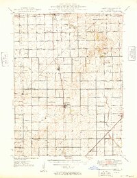
1949 Map of Sibley
USGS Topo · Published 1949About this map
Sibley serves as a central hub on this mid-century survey, surrounded by the agricultural townships of Sullivant, Fayette, and Germanville. The landscape is defined by its rural density, evidenced by a high concentration of country schools such as Happy Home Sch and Pleasant Ridge Sch that dotted the prairie before modern consolidation. Two major rail lines, the Wabash and Illinois Central, intersect the region, facilitating the movement of grain and goods from settlements like Forrest, Chatsworth, and Melvin. Natural drainage is provided by the South Fork Vermilion River and Mackinaw River, which wind through the flatlands alongside Lake Sibley. Local family and community heritage is anchored by sites like St Johns Ch and Mt Hope Cem, reflecting the deep-rooted settlement patterns of Ford, Livingston, and McLean Counties.
Find a feature on this map
72 named features on this map. Tap any name to fly to it.
Don’t see what you’re looking for? This feature index may not catch every label — zoom into the map to look around manually.
Map Details
Editions of this 1949 Sibley Map
2 editions found

Other maps of this area

1924 · Paxton
USGS Topo · 1:62,500

1927 · Paxton
USGS Topo · 1:62,500

1928 · Gibson City
USGS Topo · 1:62,500

1935 · Pontiac
USGS Topo · 1:62,500

1939 · Pontiac
USGS Topo · 1:62,500

1944 · Piper City
USGS Topo · 1:48,000

1947 · Piper City
USGS Topo · 1:62,500

1947 · Sibley
USGS Topo · 1:62,500

1947 · Cullom
USGS Topo · 1:62,500

1948 · Buckley
USGS Topo · 1:62,500