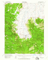
1955 Map of Sierraville
USGS Topo · Published 1960About this map
Sierra Valley and the surrounding high country of the Tahoe National Forest define this mid-century landscape. The map captures a transition in local industry, noting the Winnie Smith Mill (Ruins) and the Nichols Mill (Site), alongside active features like the Antelope Mine and Calpine Airport. Small mountain settlements including Sierraville, Sattley, and Calpine serve as hubs for the area's geography, while scattered sites like McPherrin Camp, Ahart Camp, and Church Camp suggest a history of seasonal use and remote residence.
Find a feature on this map
63 named features on this map. Tap any name to fly to it.
Don’t see what you’re looking for? This feature index may not catch every label — zoom into the map to look around manually.
Map Details
Editions of this 1955 Sierraville Map
3 editions found

Other maps of this area

1890 · Sierraville
USGS Topo · 1:125,000

1891 · Downieville
USGS Topo · 1:125,000

1891 · Colfax
USGS Topo · 1:125,000

1891 · Truckee
USGS Topo · 1:125,000

1892 · Sierraville
USGS Topo · 1:125,000

1892 · Colfax
USGS Topo · 1:125,000

1893 · Truckee
USGS Topo · 1:125,000

1893 · Downieville
USGS Topo · 1:125,000

1894 · Colfax
USGS Topo · 1:125,000

1894 · Sierraville
USGS Topo · 1:125,000