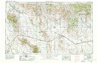
1954 Map of Silver City
USGS Topo · Published 1980About this map
Silver City and the mining operations of southwestern New Mexico anchor this high-desert landscape during a period of significant industrial activity. The massive open pits of the Tyrone Mine and Chino Mine are clearly delineated, illustrating the region's deep connection to copper extraction. The terrain is defined by the Continental Divide as it winds through the Pinos Altos Range and Gila Mountains, while to the west, the Gila River and San Simon River basins support agricultural settlements like Safford and Solomon.
Find a feature on this map
86 named features on this map. Tap any name to fly to it.
Don’t see what you’re looking for? This feature index may not catch every label — zoom into the map to look around manually.
Map Details
Editions of this 1954 Silver City Map
4 editions found

Other maps of this area

1899 · Deming
USGS Topo · 1:125,000

1902 · Clifton
USGS Topo · 1:62,500

1909 · Silver City
USGS Topo · 1:125,000

1910 · Mogollon
USGS Topo · 1:125,000

1911 · Alum Mountain
USGS Topo · 1:125,000

1912 · Mogollon
USGS Topo · 1:125,000

1913 · Alum Mountain
USGS Topo · 1:125,000

1913 · Morenci
USGS Topo · 1:125,000

1915 · Benson
USGS Topo · 1:125,000

1915 · Morenci
USGS Topo · 1:125,000