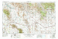
1954 Map of Silver City
USGS Topo · Published 1991About this map
Mining operations and high-desert transportation corridors dominate this mid-century survey of the Arizona-New Mexico borderlands. The region's industrial backbone is clearly visible through the concentration of heavy mineral extraction sites like the Chino Mine, Empire Zinc Mine, and the holdings of the Banner Mining Company. These enterprises are linked by the Southern Pacific RR and the Atchison Topeka and Santa Fe RR, which navigate the terrain between the Peloncillo Mountains and the Burro Mountains.
Find a feature on this map
76 named features on this map. Tap any name to fly to it.
Don’t see what you’re looking for? This feature index may not catch every label — zoom into the map to look around manually.
Map Details
Editions of this 1954 Silver City Map
4 editions found

Other maps of this area

1899 · Deming
USGS Topo · 1:125,000

1902 · Clifton
USGS Topo · 1:62,500

1909 · Silver City
USGS Topo · 1:125,000

1910 · Mogollon
USGS Topo · 1:125,000

1911 · Alum Mountain
USGS Topo · 1:125,000

1912 · Mogollon
USGS Topo · 1:125,000

1913 · Alum Mountain
USGS Topo · 1:125,000

1913 · Morenci
USGS Topo · 1:125,000

1915 · Benson
USGS Topo · 1:125,000

1915 · Morenci
USGS Topo · 1:125,000