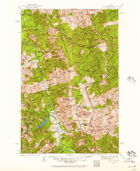
1936 Map of Silvertip
USGS Topo · Published 1957About this map
Silvertip Mtn and the high ridges of the Northern Rockies define this 1930s landscape, where remote outpost management and aviation infrastructure were critical for backcountry access. The survey highlights a network of administrative sites such as the Black Bear Guard Sta and Big Prairie Ranger Sta, supported by a series of primitive airfields including the Meadow Creek Landing Field and Bartlett Landing Field. This reliance on remote landing strips alongside traditional pack trails like the Continental Divide Trail illustrates the mid-century transition in wilderness logistics.
Find a feature on this map
183 named features on this map. Tap any name to fly to it.
Don’t see what you’re looking for? This feature index may not catch every label — zoom into the map to look around manually.
Map Details
Editions of this 1936 Silvertip Map
3 editions found
Other maps of this area

1902 · Ovando
USGS Topo · 1:125,000

1903 · Saypo
USGS Topo · 1:125,000

1903 · Coopers Lake
USGS Topo · 1:125,000

1905 · Ovando
USGS Topo · 1:125,000

1913 · Marias Pass
USGS Topo · 1:125,000

1914 · Nyack
USGS Topo · 1:125,000

1914 · Heart Butte
USGS Topo · 1:125,000

1918 · Heart Butte
USGS Topo · 1:125,000

1921 · Elbow Lake
USGS Topo · 1:125,000

1936 · Silvertip
USGS Topo · 1:96,000