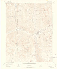
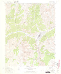
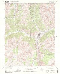
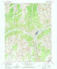
1955 Map of Silverton
USGS Topo · Published 1957About this map
Silverton serves as the industrial and logistical hub of the San Juan Mountains in the mid-1950s, its narrow valley packed with the infrastructure of a legacy mining economy. The Denver and Rio Grande Western railroad tracks follow the Animas River into town, meeting a network of roads and the Million Dollar Highway that connect remote high-altitude operations. The map reveals an incredible density of mining activity, from the Mayflower Mill and Lackawanna Mill to scattered extraction sites like the Henrietta Mine and Scranton City Mine perched in steep gulches. Beyond the main settlement, the smaller site of Chattanooga sits along Mineral Creek, while the Hillside Cem and the Airstrip indicate the evolving needs of this mountain community. The landscape is defined by massive peaks including Anvil Mountain and Sultan Mountain, where a complex system of Jeep Trails and Pack Trails provided the only access to the rugged interior of the San Juan National Forest.
Find a feature on this map
80 named features on this map. Tap any name to fly to it.
Don’t see what you’re looking for? This feature index may not catch every label — zoom into the map to look around manually.
Map Details
Editions of this 1955 Silverton Map
7 editions found
Other maps of this area

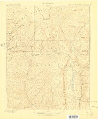
1897 · Telluride
USGS Topo · 1:62,500

1897 · Silverton
USGS Topo · 1:62,500

1898 · Engineer Mountain
USGS Topo · 1:62,500

1900 · Engineer Mountain
USGS Topo · 1:62,500

1900 · Needle Mountains
USGS Topo · 1:62,500

1901 · Silverton
USGS Topo · 1:62,500

1902 · Needle Mountains
USGS Topo · 1:62,500

1902 · Silverton
USGS Topo · 1:62,500

1904 · Telluride
USGS Topo · 1:62,500
1908 · Engineer Mountain
USGS Topo · 1:62,500