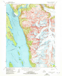
1948 Map of Skagway A-1
USGS Topo · Published 1972About this map
Tongass National Forest dominates the maritime landscape of this coastal survey, where the glacial ice of Meade Glacier feeds into the silt-laden waters of the Katzehin River. The map illustrates the complex hydrography of the Lynn Canal system as it branches into Chilkoot Inlet and Chilkat Inlet, separated by the high ridges of the Chilkat Peninsula. Maritime navigation aids like Berry Light and various beacons mark the safe passage through the Chilkat Islands, including Sullivan Island and Kataguni Island. The transition from the massive ice fields of the interior to the deep-water fjords is captured through high-elevation landmarks such as Sinclair Mtn. These 1948 photogrammetric records show the coastline and glacial boundaries before mid-century shifts, providing a precise baseline for the region's wilderness geography.
Find a feature on this map
26 named features on this map. Tap any name to fly to it.
Don’t see what you’re looking for? This feature index may not catch every label — zoom into the map to look around manually.
Map Details
Editions of this 1948 Skagway A-1 Map
3 editions found
Other maps of this area

1948 · Juneau D-3
USGS Topo · 1:63,360

1948 · Skagway A-1
USGS Topo · 1:63,360

1949 · Atlin
USGS Topo · 1:250,000

1949 · Juneau D-5
USGS Topo · 1:63,360

1949 · Skagway B-1
USGS Topo · 1:63,360

1949 · Juneau D-4
USGS Topo · 1:63,360

1949 · Juneau D-3
USGS Topo · 1:63,360

1951 · Juneau
USGS Topo · 1:250,000

1951 · Skagway A-1
USGS Topo · 1:63,360

1951 · Atlin
USGS Topo · 1:250,000