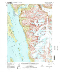
1948 Map of Skagway A-1
USGS Topo · Published 1972About this map
Tongass National Forest dominates the maritime landscape of this 1948 topographic study, where the peaks of the Coast Range meet the deep glacial waters of Southeast Alaska. The map centers on the convergence of the Chilkoot Inlet and Chilkat Inlet as they flow into the broader Lynn Canal. This area is defined by its dramatic verticality, from the icy expanse of the Meade Glacier and the silt-laden mouth of the Katzehin River to the prominent heights of Sinclair Mtn. Along the coast, numerous small islands including Sullivan Island, Shikosi Island, and Kataguni Island offer a detailed view of the complex shoreline geography. For researchers, the map provides precise locations for coastal landmarks such as Battery Point and Seduction Point, alongside inland features like Rustabach Lake.
Find a feature on this map
25 named features on this map. Tap any name to fly to it.
Don’t see what you’re looking for? This feature index may not catch every label — zoom into the map to look around manually.
Map Details
Editions of this 1948 Skagway A-1 Map
3 editions found
Other maps of this area

1948 · Juneau D-3
USGS Topo · 1:63,360

1948 · Skagway A-1
USGS Topo · 1:63,360

1949 · Atlin
USGS Topo · 1:250,000

1949 · Juneau D-5
USGS Topo · 1:63,360

1949 · Skagway B-1
USGS Topo · 1:63,360

1949 · Juneau D-4
USGS Topo · 1:63,360

1949 · Juneau D-3
USGS Topo · 1:63,360

1951 · Juneau
USGS Topo · 1:250,000

1951 · Skagway A-1
USGS Topo · 1:63,360

1951 · Atlin
USGS Topo · 1:250,000