
1954 Map of Skagway A-2
USGS Topo · Published 1959About this map
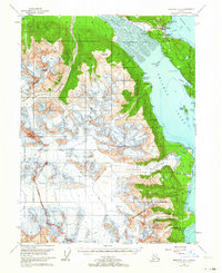
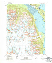
Haines and Port Chilkoot occupy the strategic Deshu Isthmus in this mid-1950s survey, serving as a gateway between the maritime world of Chilkoot Inlet and the inland reaches of the Chilkat River. The landscape is dominated by the immense glacial systems of the Chilkat Range, including the expansive Davidson Glacier and the crevassed fields of Garrison Glacier. This edition records the infrastructure of the era, from the Haines Highway winding along the river to a pipeline, Tanks, and a Landing Field near the settlement. Along the coast, the economic character of the region is evident at Pyramid Harbor and a Cannery at Letnikof Cove, while the southwestern corner of the sheet transitions into the protected wilderness of Glacier Bay National Monument.
Find a feature on this map
51 named features on this map. Tap any name to fly to it.
Don’t see what you’re looking for? This feature index may not catch every label — zoom into the map to look around manually.
Map Details
Editions of this 1954 Skagway A-2 Map
3 editions found
Other maps of this area

1948 · Skagway A-1
USGS Topo · 1:63,360

1949 · Juneau D-6
USGS Topo · 1:63,360

1949 · Juneau D-5
USGS Topo · 1:63,360

1949 · Skagway B-1
USGS Topo · 1:63,360

1951 · Juneau
USGS Topo · 1:250,000

1951 · Skagway A-1
USGS Topo · 1:63,360

1951 · Skagway B-1
USGS Topo · 1:63,360

1952 · Skagway
USGS Topo · 1:250,000

1954 · Skagway B-2
USGS Topo · 1:63,360

1954 · Skagway A-3
USGS Topo · 1:63,360