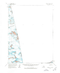
1961 Map of Skagway A-7
USGS Topo · Published 1977About this map
Grand Pacific Glacier dominates this high-altitude survey of the international border between Alaska and British Columbia. Mapping the western reaches of what was then known as Glacier Bay Nat Monument, this document records the ice-covered divide through the Fairweather Range. Several prominent peaks serve as markers for the United States Canada boundary, including Mt Lodge Boundary Peak 166, Mt Hay Boundary Peak 167, and Boundary Peak 162 Mt Turner. The map illustrates a landscape shaped almost entirely by glaciology, where the ice fields of the Grand Pacific Glacier connect high mountain summits like Mt Watson across the border. These 1961 annotations provide a specialized look at the geodetic markers and ice elevations along the frontier before the monument's eventual expansion and change in status.
Find a feature on this map
9 named features on this map. Tap any name to fly to it.
Don’t see what you’re looking for? This feature index may not catch every label — zoom into the map to look around manually.
Map Details
Editions of this 1961 Skagway A-7 Map
2 editions found
Other maps of this area

1951 · Mt Fairweather
USGS Topo · 1:250,000

1952 · Skagway
USGS Topo · 1:250,000

1961 · Skagway A-7
USGS Topo · 1:63,360

1961 · Mount Fairweather D-4
USGS Topo · 1:63,360
1961 · Skagway A-6
USGS Topo · 1:63,360

1961 · Mount Fairweather D-5
USGS Topo · 1:63,360
1961 · Skagway B-8
USGS Topo · 1:63,360

1961 · Skagway A-8
USGS Topo · 1:63,360

1961 · Mt Fairweather
USGS Topo · 1:250,000

1961 · Skagway
USGS Topo · 1:250,000