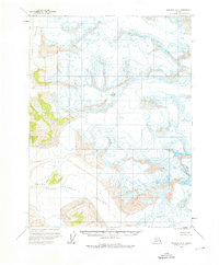
1961 Map of Skagway A-8
USGS Topo · Published 1976About this map
Grand Plateau Glacier and the adjacent Alsek Glacier dominate this 1961 field-annotated landscape in the Saint Elias Mountains region. This survey, compiled from aerial photography taken in the late 1940s and early 1950s, documents a wilderness of ice and rock before significant modern glacial recession. The map shows the massive Grand Plateau as a prominent topographical landmark, with the sheet's surface marked by numerous Crevasses that indicate the active movement of these ice fields. Because the area remained largely unsurveyed on the ground, the Bureau of Land Management predetermined land lines that appear as markers across the frozen terrain, providing a rare look at how administrative boundaries were projected over a roadless and uninhabited glacial environment.
Find a feature on this map
4 named features on this map. Tap any name to fly to it.
Don’t see what you’re looking for? This feature index may not catch every label — zoom into the map to look around manually.
Map Details
Editions of this 1961 Skagway A-8 Map
2 editions found

Other maps of this area

1951 · Yakutat
USGS Topo · 1:250,000

1951 · Mt Fairweather
USGS Topo · 1:250,000

1952 · Skagway
USGS Topo · 1:250,000

1959 · Yakutat A-1
USGS Topo · 1:63,360

1959 · Yakutat B-1
USGS Topo · 1:63,360

1959 · Yakutat
USGS Topo · 1:250,000
1961 · Mount Fairweather D-7
USGS Topo · 1:63,360

1961 · Skagway A-7
USGS Topo · 1:63,360

1961 · Mount Fairweather D-6
USGS Topo · 1:63,360

1961 · Mount Fairweather D-5
USGS Topo · 1:63,360