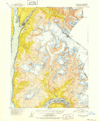
1951 Map of Skagway B-1
USGS Topo · Published 1952About this map
The port of Skagway serves as the gateway to the interior in the early 1950s, positioned where the Taiya River and Skagway River meet the head of Taiya Inlet. The critical logistical role of the town is evidenced by the White Pass and Yukon River railroad winding north through the Coast Ranges toward the Canadian border. This survey reflects a landscape shaped by ice and elevation, dominated by the Denver Glacier and South Glacier within the Tongass National Forest. Local landmarks like Reid Falls and the tiered waters of Lower Dewey Lake and Upper Dewey Lake sit just above the settlement, while the international boundary with British Columbia is marked by high-altitude survey points such as Boundary Pk 111 and Boundary Pk 109. The southern portion of the map is defined by the braided channels of the Katzehin River, illustrating the dynamic glacio-fluvial environment of Southeast Alaska.
Find a feature on this map
30 named features on this map. Tap any name to fly to it.
Don’t see what you’re looking for? This feature index may not catch every label — zoom into the map to look around manually.
Map Details
Editions of this 1951 Skagway B-1 Map
2 editions found
Other maps of this area

1948 · Skagway C-2
USGS Topo · 1:63,360

1948 · Skagway A-1
USGS Topo · 1:63,360

1948 · Skagway C-1
USGS Topo · 1:63,360

1949 · Atlin
USGS Topo · 1:250,000

1949 · Skagway B-1
USGS Topo · 1:63,360

1951 · Skagway A-1
USGS Topo · 1:63,360

1951 · Skagway C-1
USGS Topo · 1:63,360

1951 · Atlin
USGS Topo · 1:250,000

1951 · Skagway B-1
USGS Topo · 1:63,360

1951 · Skagway C-2
USGS Topo · 1:63,360