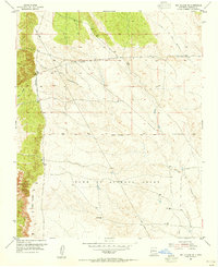
1954 Map of Sky Village SE
USGS Topo · Published 1955About this map
The Town of Alameda Grant defines the southern half of this landscape, showing the persistent influence of Spanish land grants on New Mexico's mid-century geography. In the early 1950s, this area of Sandoval County was characterized by arid land management, featuring a long Aqueduct and a Pipe Line cutting through the terrain to service isolated Water Tanks. The topography is dominated by dry washes, most notably the winding Arroyo de las Calabacillas and Arroyo de los Montoyas. Human presence is marked by livestock infrastructure like Centipede Well and the aptly named Mentira Well (Dry). The map records a series of surveyor markers along the Grant Boundary, illustrating the precise delineation of these historical land tracts as they were managed by the Department of the Interior during this era.
Find a feature on this map
11 named features on this map. Tap any name to fly to it.
Don’t see what you’re looking for? This feature index may not catch every label — zoom into the map to look around manually.
Map Details
Editions of this 1954 Sky Village SE Map
2 editions found
Other maps of this area

1888 · Bernalillo
USGS Topo · 1:125,000

1889 · Albuquerque
USGS Topo · 1:125,000

1893 · Albuquerque
USGS Topo · 1:125,000

1934 · Griegos
USGS Topo · 1:24,000

1938 · Albuquerque
USGS Topo · 1:62,500

1953 · Bernalillo NW
USGS Topo · 1:24,000

1954 · Volcano Ranch
USGS Topo · 1:24,000

1954 · Loma Machete
USGS Topo · 1:24,000

1954 · Sky Village
USGS Topo · 1:24,000
1954 · Los Griegos
USGS Topo · 1:24,000