
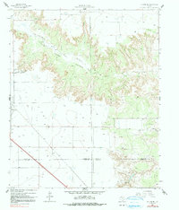
1965 Map of Slaton NE
USGS Topo · Published 1966About this map
Yellow House Canyon dominates this 1960s landscape, carved by the North Fork Double Mountain Fork Brazos River as it winds through the high plains of West Texas. On the western edge, the city of Slaton serves as a hub where Slaton Road and a major Pipeline converge near the railroad tracks of the Atchison Topeka and Santa Fe. The map provides a detailed look at the rural economy of the era, illustrating the transition from the municipal infrastructure of Slaton to large ranching operations like the Wood Ranch, V Ranch, and Katy K Ranch. The industrial footprint of the region is evident through scattered Claypits, Gravel Pits, and a Quarry, while the jagged terrain of Long Hollow Canyon and the headwaters of Spring Creek showcase the erosional forces that define this portion of the Llano Estacado.
Find a feature on this map
22 named features on this map. Tap any name to fly to it.
Don’t see what you’re looking for? This feature index may not catch every label — zoom into the map to look around manually.
Map Details
Editions of this 1965 Slaton NE Map
2 editions found
Other maps of this area

1954 · Lubbock
USGS Topo · 1:250,000

1965 · Acuff
USGS Topo · 1:24,000

1965 · Slaton
USGS Topo · 1:24,000

1965 · Buffalo Springs Lake
USGS Topo · 1:24,000

1965 · Southland
USGS Topo · 1:24,000

1965 · Wilson
USGS Topo · 1:24,000

1966 · Cap Rock
USGS Topo · 1:24,000

1967 · Savage
USGS Topo · 1:24,000

1968 · South Dokegood Creek
USGS Topo · 1:24,000
1986 · Slaton
USGS Topo · 1:100,000